By María Sahuquillo, Conservadora del Parque Natural de l’Albufera
The Albufera de Valencia, part of the MedWet Managers Network, illustrates the vital role of coastal wetlands in buffering against floods. Located in the lower parts of river basins, these wetlands can temporarily store large volumes of water and release it gradually. The Iberian Peninsula, the Mediterranean coast—where tides are minimal—is particularly rich in such systems. The Albufera, in the central Gulf of Valencia, is the best-known wetland; however, it forms a continuous system with surrounding marshes, together forming a wide natural floodplain.
This hydrological complex covers about 25,000 hectares of potentially floodable land. Rivers and ravines are linked by an intricate network of irrigation channels and canals that reach the natural outlets to the sea. The area includes the final stretch of the Júcar River and the Ribera plain, a region with abundant historical and paleohydrological evidence of hundreds of floods over the centuries.
Today, this natural buffering function faces increasing pressures. Extreme weather events are becoming more frequent and intense, while infrastructure such as roads and highways can block or restrict natural water flow, reducing the wetlands’ ability to attenuate floods and drain excess water.
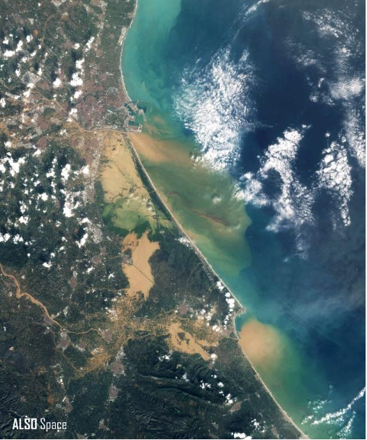
The DANA (intense localised storm) of 29 October 2024 was an extreme event, with over 700 mm of rainfall in 24 hours in mid-basin areas. Intermittent channels like the Barranco del Poyo went from nearly dry to roughly 2,300 m³/s, and combined flows from other ravines exceeded 3,000 m³/s. In some measuring stations, these flows far surpassed previous decades’ maximums, confirming the exceptional nature of the storm. Landsat 8 images the following day revealed extensive flooding in the Albufera and coastal agricultural areas. The wetlands absorbed a large part of the water and sediment, reducing damage in urban areas. Three main overflow zones were observed: north at the Barranco del Poyo, the Magro River towards the Sueca–Sollana rice fields, and the Marjal and Estany de la Ribera Sud wetland.
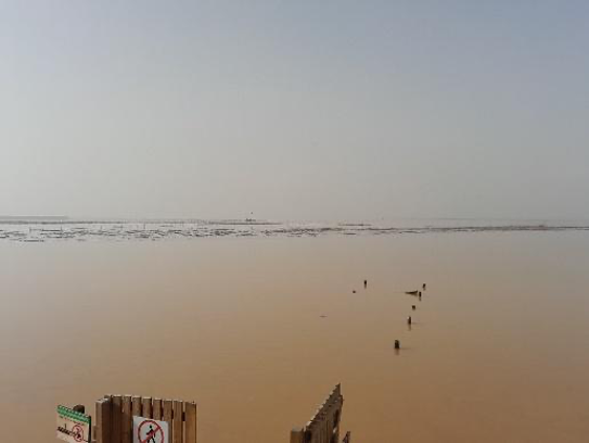
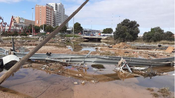
In just a few hours, the Albufera accumulated 60% of the water it normally collects. In the lagoon and marshes, water levels rose by 1 meter in 11 hours and took 1 month to return to their previous levels. Upstream, the Barranco del Poyo rose 3.5 meters in only half an hour. Although the wetland acted as a natural buffer, the storm’s exceptional intensity caused sudden disruptions: massive sediment movement, damage to hydraulic infrastructure, and silted channels and canals. Flooding in the south, mainly affecting farmland, caused limited damage, while the northern overflow hit highly impermeable areas with obstructed flows, moving vehicles and debris and causing severe damage, including human fatalities.
The October 2024 DANA was estimated to be about 20% more intense due to climate change. This event highlights that although wetlands play a crucial role in reducing flood impacts, their capacity can be exceeded during extreme weather events—especially as such events become more frequent and intense. It also underscores how linear infrastructures, such as roads, railways, and embankments, can significantly alter natural water flows and influence flood dynamics.
These observations reinforce the importance of restoring wetland areas and, importantly, the wider river basins in which they operate. Strengthening natural hydraulic networks, reconnecting rivers to their floodplains, and applying adaptive management practices are essential for maintaining the water retention capacity and overall resilience of wetlands. Such measures help ensure that wetlands continue to act as effective buffers against floods while supporting biodiversity and providing vital ecosystem services.